
A dedicated application to port services, which integrates all aspects of operational management and navigation safety, through cartography
Directors of operations, managers, harbourmasters, pilots, hydrographers… in a port, cartographic functions meet a multitude of needs in an extremely dense area of activity.
Managing these challenges through a unified and collaborative Geographic Information System (GIS) improves the performance of everyone.
Indeed, all business lines contribute to creating or collecting information, whether to make day-to-day decisions or to plan longer-term projects. And naturally, you need a tool that allows you to access this information in real time.
That tool is PortAll® from GEOMOD, a software publisher specializing in geomatics. This web application will integrate all aspects of the operational management and navigational safety of your port, through cartography.
An unparalleled innovative solution!
PortAll is organized in modules in order to adapt to the different occupations: hydrographers, captains, pilots, skippers, boatage services… while allowing them to share the same data.
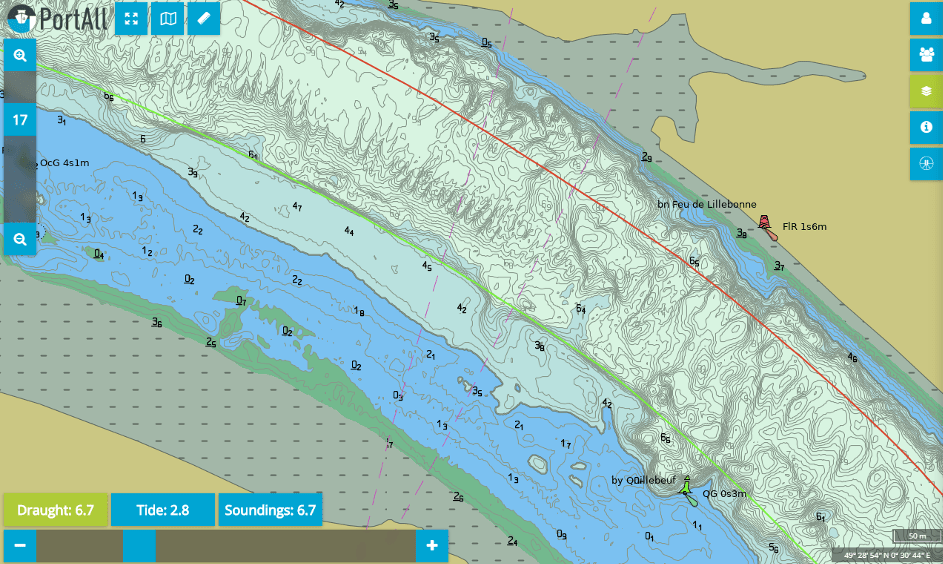
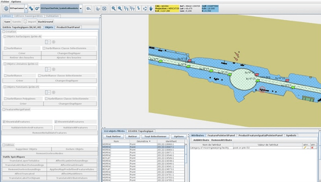
To set up the GIS environment, we will build a cartography of the facilities and the body of water. PortAll integrates the famous ULHYSSES module allowing the fully automatic creation of the most accurate, up-to-date and fast bathymetry! As soon as the hydrographer has validated the bathymetry produced, the data is instantly available to all users. Pilots can also download the set of bathymetric charts (bENC in S-57 format) to install them on their PPU (Portable Pilot Unit).
Automatic data (AIS, anemometers, tide gauges…) are also integrated and shared in real time.
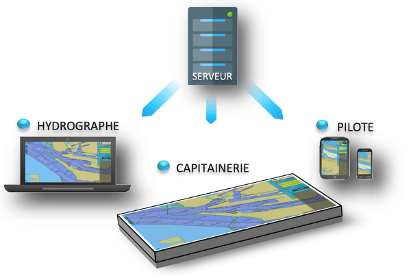
The information is hosted on a server. They are therefore accessible from anywhere and at any time, with a simple internet connection. No software to install, no license, no updates: by its features and performances, PortAll is without equivalent on the market!
A real business application
Thanks to its modular architecture, PortAll allows all stakeholders, hydrographers, harbour masters and harbour pilots to benefit from functionalities specific to their activity. But we know that to be effective, information must be both relevant and intelligible.
This is why we have paid particular attention to ergonomics. PortAll adapts to the user: contextual menus provide the information you need at all times. And because it is designed as a “responsive” application, the interface also adapts to your medium: large screen, touch tablet or smartphone.
Finally, PortAll manages cross-functional information and allows everyone to share annotations with other departments or colleagues in their own department.
The hydrograph
From his computer, the hydrographer automatically produces and updates the bathymetric coverage as he conducts his surveys and makes them immediately usable by other services. Drivers can then download the set of bathymetric charts (bENC in S-57 format) to install them on their PPU (Portable Pilot Unit).
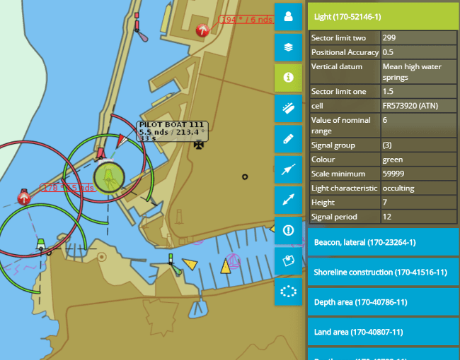
It can also manage georeferenced information such as information notes (point, circle, polygon), obstructions, various notices, which are immediately visible and retrievable by all other authorized users.
The harbour master
The harbour master’s office uses the most accurate and up-to-date bathymetry on a touch table. It adjusts the usual safety contour according to the draught, as well as the second safety contour gained by the tide. It manages the location of vessels via templates that move with two fingers on the touch screen. It can display real time data (AIS, cranes, etc.), as well as any other shared data (obstructions, quotes, etc.).
The pilot
Smartphone or mini tablet in his pocket, the pilot gets on board with all the most accurate and up-to-date data (port charts, bathymetry, quotations, notes and notices, obstructions) as well as real-time data (AIS, anemometers, tide gauges…). PortAll is then the communication tool to present the manoeuvre to the captain, by plotting the envisaged route, displaying an adapted passage plan, interrogating the anemometers, visualising the safe waters (draught and tide), etc. With PortAll, the pilot can define guard zones, calculate ETAs, display COG & SOG, query AIS, etc.
The pilot also uses Portall in mission preparation, he can also use it to debrief at the end of the mission, with the captain or his colleagues, in particular by using the replay capability. For example, PortAll can be used to record the last 24 hours of real-time data (AIS, anemometers, etc.), which can then be used to replay all or part of a mission, a function that is particularly useful in the event of an incident in order to analyse its causes.
The portside option, the S-57 precision
For the hydrographic service that wishes to create its own harbour charts, more accurate than official charts and containing the objects of interest to harbour pilots, Deparentis also distributes the PortSide® software.
PortSide allows the creation and modification of data sets in S-57 format: Electronic Navigational Charts (ENC, IENC) for marine, port or river navigation, as well as AML vector layers. Developed in java, it is the result of Geomod’s expertise in the exploitation of hydrographic data and in the IHO/IMO standards: S-57, S-52, S-63, S-68, etc.
Using our own PortSide software, we can initialize and produce the first series of accurate port charts in S-57 format, a task that requires a high level of knowledge and expertise in electronic nautical charts and IHO standards. We can then maintain and update these charts, or we can provide training on PortSide for those in the port who wish to update these charts themselves.
A tailor-made offer, as close as possible to your needs
We accompany you in all phases of the project. From the definition of needs and the creation of the geographic information system to the training of personnel, Geomod and Deparentis bring their expertise.
For the implementation of the PortAll solutions and the PortSide option, we remain at your disposal to adapt our offer, integrate, configure, and possibly develop tailor-made functionalities.
And if you wish to offload its administration, we can host the service securely on our servers.
Choose the right tool for your port and gain in comfort, productivity and security.