
Control the safety of your maritime environment. With Vesper, deploy virtual aids to navigation with a fingertip.
To signal a danger, delimit a channel and ensure safe navigation, seamarks are essential. However, the deployment and maintenance of these beacons or buoys can be costly and difficult.
Virtual buoys, a high-performance alternative
Sometimes the access or installation conditions at sea or on the coast of a physical mark can be dangerous. In other circumstances, accurate information is needed more quickly than a buoy can be installed. For example, in a river where sandbanks are moving, requiring constant repositioning of markings, or as an emergency warning of a new hazard to navigation.
In these situations, virtual buoyage, otherwise known as “Virtual Aid to Navigation” (VAtoN) may be a solution.
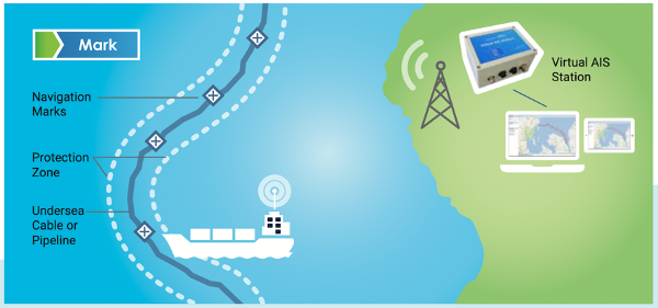
A virtual buoy does not physically exist. It is a digital information object that is automatically displayed on the navigation systems of vessels in the area. In concrete terms, a shore-based radio broadcasts a signal via VHF that assigns information – mark, danger, cardinal – to a position – in latitude and longitude. Depending on the conditions, the range of the signal can reach 25 nautical miles.
This information is distributed according to the Automatic Identification System (AIS) protocol, which is a mandatory device on vessels over 300T gross tonnage and passenger vessels of all sizes. Vessels present in the area can then see this virtual buoyage on their Electronic Chart Display and Information System (ECDIS).
Virtual buoyage, a safe alternative
In addition to their lower cost, maintenance free and faster deployment, the use of virtual aids to navigation has safety advantages.
To begin with, virtual aids to navigation are not sensitive to weather conditions and are always accurately displayed on a ship’s ECDIS: the information is not altered and, unlike a physical buoy that can disappear or drift, a virtual buoy maintains its position in all circumstances.
Then, with a radio range greater than the visibility of a physical buoy, the information is delivered with more clarity and allows for early positive identification. This is true at sea, but navigation on islands or in rivers particularly highlights this advantage: a virtual buoy is not masked by the terrain and allows the navigator to have a better situational awareness.
Synthetic aton, the best of both worlds
There are technical solutions for every need. These range from physical AtoN (floating buoy with its mark) to AIS AtoN (floating buoy + integrated AIS transmitter) with or without autonomous light, to virtual AtoN (digital information object by remote AIS transmitter).
It is also possible to combine a physical and a virtual mark on the same position, thus creating a “synthetic AtoN”.
The AIS information is broadcasted by VHF from a land station, according to the virtual buoyage process, but to an offshore position occupied by a physically existing buoy. The information then appears to come from the location of the buoy itself.
From the vessel’s bridge, the pilot can see the buoy in its environment while chart plotters, radar or other navigational displays show the AIS information of the buoy at the location where it is charted.
This synthetic buoyage solution can be useful to prevent vandalism and reduce maintenance costs compared to buoys with integrated AIS, or to upgrade an existing AtoN network.
Marine Vesper solutions
Deparentis is a distributor of Vesper Marine®. Through its different services Guardian:mark Guardian:monitor and Guardian:protect, Vesper Marine has established itself as a leader in navigational aid and virtual beaconing solutions.
With Vesper Marine we make hazards at sea visible when physical buoys are unsuitable, expensive or impossible to deploy. By combining our shore-based virtual AIS station with cloud-based software, we leverage the best of technology. It can be accessed simply, anywhere, anytime through a web browser. It is then possible to emulate up to 65 virtual buoys, delete or change their position on the fly, depending on changing conditions such as tide, wrecks or temporary safety zones.
We offer professional and International Maritime Organization (IMO) and International Association of Lighthouse Authorities (IALA) approved solutions to support organizations in the oil and gas, energy, fisheries, hydrographic, pilot or port sectors to enhance the safety of people and assets.
Téléchargez les brochures :
![]()
![]()